


Tagofy is a tool designed for those who need to take photos with contextual information embedded directly in the image. This app allows you to add GPS coordinates, maps, dates and times to each photo without needing to edit them afterwards. This is perfect for engineers, inspectors, field workers, travelers or anyone who needs clear, verifiable and well-organized photographic evidence.
Photography with automatic location, date and time stamps
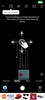
Tagofy's main function is to embed key information from the moment a photo is taken directly into the image. This includes the exact location with its latitude and longitude, physical address, date, time and even the name of the city or area. All this will be visible on the photo as if it were a custom watermark, which makes this app a very useful tool for reports, audits or technical documentation.
Display your geographic location with the embedded mini-map
Another of the app's key features is the ability to add a real-time mini GPS map over the photo, which will show the exact point where it was taken. This map view, which can be customized in terms of style (satellite, hybrid, normal, etc.), provides immediate visual context about the location, which is very useful for field validations or field reports.
Customize stamps and the visual style
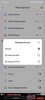
Tagofy also allows you to customize every aspect of the data stamp. Change the color of the text, the size, the font type, the position in the image, the date and time format and even which data to include or exclude in each photo from the settings. This gives you full control over how the information in your images will appear, adapting it to both aesthetic criteria and formal or work requirements.
Download the free Tagofy APK and take pictures with all the contextual information you need to add. Create a completely custom library and never forget any relevant data from any photo you take.
Requirements (Latest version)
- Android 7.0 or higher required
Comments
There are no opinions about Tagofy yet. Be the first! Comment